Get ready to experience very heavy rain and high winds in New York City on Tuesday as Tropical Storm Isaias advances up the Eastern Seaboard.
The five boroughs are under a tropical storm warning, which means that conditions for a storm within the next 36 hours are imminent. Isaias, which strengthened into a hurricane but weakened back into a tropical storm, is currently churning off the northern Florida coast. He’s forecast to become a hurricane again later today before weakening once more and making landfall in the Carolinas.
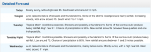
The city is expected to begin feeling Tropical Storm Isaias’ wind and rain on Tuesday morning. The National Weather Service forecasts that the five boroughs could see between 2 and 4 inches of rain; some isolated spots could experience rainfall totals of up to 6 inches.
Letter from PSEG ahead of the storm:
As Tropical Storm Isaias continues to move up the East Coast, we are closely monitoring it for potential impacts to our area. Heavy rain and strong winds could cause tree limbs to break and pull down wires, causing outages.
The energy grid is stronger and more resilient today because of our years of storm hardening projects, enhanced tree maintenance and other efforts. All personnel are ready to respond safely and as quickly as possible to any outages that occur.
Safety is always our top priority. We have incorporated public health best practices into our storm procedures, including the use of personal protective equipment and social distancing. During these difficult times, we remain committed to providing safe, reliable electric service and strong storm response.
—-
Peak Wind Forecast: 45-55 mph with gusts to 75 mph – Window for Tropical Storm force winds: Tuesday morning until Tuesday evening.
POTENTIAL IMPACTS: Significant – Some damage to roofing and siding materials, along with damage to porches, awnings, carports, and sheds. A few buildings experiencing window, door, and garage door failures. Mobile homes damaged, especially if unanchored. Unsecured lightweight objects become dangerous projectiles. – Several large trees snapped or uprooted, but with greater numbers in places where trees are shallow-rooted. Several fences and roadway signs blown over. – Some roads impassable from large debris, and more within urban or heavily wooded places. A few bridges, causeways, and access routes impassable. – Scattered power and communications outages, but more prevalent in areas with above-ground lines.